My fascination with the Dalton and Dempster Highways began about 12 years ago while glancing through a road atlas. My eyes were drawn to the edge of the map, where two roads pierced the northern extremes of civilization and ventured into the arctic. I knew I wanted to see them, for no other reason than their unique location. If it was possible to drive to the end of the world, why wouldn’t you?
The Dalton Highway stretches 414 miles from Livengood (just north of Fairbanks) to Deadhorse, Alaska. It is almost completely unpaved, built to bring equipment and supplies to oil deposits near the Arctic Ocean and the pipeline that carries the oil southward. The Dempster Highway is a 457 mile dirt road that starts near Dawson City, Yukon and ends in Inuvik, Northwest Territories. A newly-opened paved extension between Inuvik and Tuktoyaktuk carries the isolated road to the shores of the Arctic Ocean. These roads are the only two which cross the Arctic Circle in North America.
My friend Jake Bear shares my fascination for remote highways. Jake’s soul lives on the road. He estimates that he has driven 1.3 million miles in the last 20 years (“I stopped counting after a million,” he told me over beer on the last day of the trip). We have been friends since 2005, while I was still in high school and he was a recently-graduated engineer.
The following summer, we went on a road trip through the southwest US. Armed with a camera gifted to me by my parents after graduating high school, that trip was a formative experience. It solidified my interest in photography and my love of the road. Since then, Jake and I have been frequent road trip partners, pushing the boundaries of ourselves and our cars to see the most unique locations on Earth.
Newly freed from what he saw as a shackling 9-to-5 job, Jake proposed the foundation of this trip to me last year. Jake now buys, sells, and restores license plates and highway signs for a living, so his travel schedule is set by the timing of collector shows. He had to be in Calgary in May, and it was a good enough excuse to venture much further north.
Our car of choice for this journey was Jake’s trusty 2003 Toyota 4Runner. In the ten months between purchase and our trip, he added 60000 miles to its odometer. He even tore out the back seats and replaced them with a bed. Getting into said bed involves moving all cargo to the front of the car and “army crawling” over the driver’s seat, but that’s cheaper than a hotel.
The only mechanical issue Jake had with his car since he bought it was due to a collision with a deer, which had left it with no grill and a hood held down by two bungee cords laced together in an x-shaped pattern. At one border crossing later in the trip, when Jake explained that he restored old license plates, the US border patrol agent quipped “maybe you should restore your car instead.” The damage was a conversation piece (even more than the California license plate), every passing adventurer wanted to know what Jake hit, but it was only cosmetic. Significantly cosmetic, but everything still worked. The rugged nature of the car was a fitting foreground for what laid ahead.
We didn’t take our impending trials lightly, so we set out with three full-size spare tires and 15 gallons of extra gas ratchet-strapped to the roof. It was barely enough.
—
Driving the Dalton Highway was like descending through the stages of road hell (fitting, then, that it is 666 kilometers long). The first circle was the glare. Arctic sunsets take their time. They linger. It’s beautiful if you’re not driving towards it, but our first 100 miles were pointed in that precise direction.
Next came the potholes. This section is paved, but it was so bad that we wished it wasn’t. It was like driving through a minefield of wheel-destroying chasms. The glare made things even worse. When you’re straining to see, it’s nearly impossible to read the road’s surface. You will hit potholes here, it’s just a matter of picking the least bad ones to hit.
Next came the dust. The Dalton is a significant truck route, a conduit of important supplies for the oil fields of Prudhoe Bay. These trucks kick up dust and rocks, making it extremely difficult to see when you’re near them. Making matters worse, the rear window of our car wasn’t completely sealed due to a previous owner’s accident. That invited the dust to invade our existence. We breathed in the dust, we slept in the dust. There was no escape from the dust.
The Dalton crosses the Arctic Circle at the end of this stretch and mercifully changes direction, making the endless sunset less of an issue. A monument congratulated us on crossing the circle and surviving the first quarter of the road, but it didn’t mention that the worst was still to come.
The Dalton isn’t bad in every aspect. Its midpoint is the town (read: truck stop) of Coldfoot, located 60 miles north of the Arctic Circle. We made camp in our car there on the first night. The Dalton’s best road conditions are found on the 50 miles on either side of this oasis, as if the road was rolling out the red carpet for its only real civilization.

The Red Carpet
Coldfoot has a 24 hour gas station, a hotel, and a restaurant. They even serve craft beer, naturally brewed at “the most northern brewery in America.” Gas costs $5.74 per gallon, yet another reminder of the remote location. The truck stop is muddy and dingy, but it definitely fits under the adage “any port in a storm.”
The best scenery on the Dalton is the Atigun Pass north of Coldfoot, where the road climbs over the top of the Brooks Range and crosses the Pacific/Arctic Ocean continental divide. Signs warn drivers to not stop and take pictures due to the risk of avalanches. The peaks surrounding the highway showed signs of those avalanches occurring, the snow obviously disturbed from its original state. Even knowing that risk, it’s hard not to stop and stare.

Atigun Pass
However, the worst circle of driving hell was found on the northern side of the pass in the flat, dreary stretch from there to Deadhorse. There are no trees, just infinite stretches of tundra and marsh. Our drive northward had been free of car problems to this point, but the Dalton decided that it was time to fight back.
The road descending the North Slope is built upon a bed of permafrost. The tricky terrain and severe temperature changes lead to frequent potholes. For some reason, these holes are filled with extremely sharp rocks. They would have been better off using knives.
This section of road is littered with evidence of 18-wheelers becoming 17-wheelers, tire treads strewn about the shoulder haphazardly. One hole in the road was not entirely filled, and the truck wheel it destroyed was placed inside of it as a warning. The wheel was dutifully replaced by a traffic cone by the time we drove south.
We lost our first tire in this stretch, about 100 miles south of Deadhorse on the downslope of the dreadfully-named “oil spill hill.” The spare tire we used to replace it had a leak, but that leak was slow enough that we were able to nurse it to the end of the road, filling it once with our compressor on the way. While we refilled the spare, we noticed that another tire had also developed a leak, so we had to fill that one as well. We were dragging our back wheels to the finish line.

The Knives
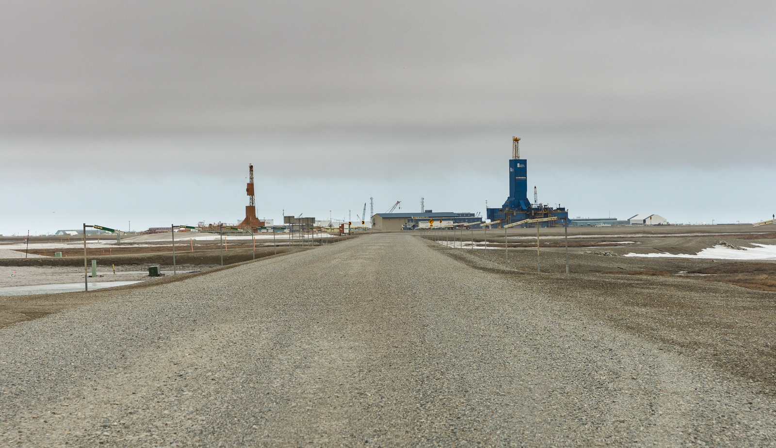
We arrived in Deadhorse six hours after we departed Coldfoot that morning. We imagined that it would be a welcoming sight, a much-needed break from our frustrating journey. We were wrong. The marine layer from the nearby Arctic Ocean hung over the town. Combined with the industrial skyline, Deadhorse looked like a caricature of a town built entirely to support the oil industry, rather than what we hoped would be our tire-filled salvation.
Deadhorse’s infrastructure doesn’t welcome outsiders. The only hint of tourism was a poster for oil-company led tours to the ocean, which is inaccessible to the public. We arrived about eight hours after the town’s last sunrise until late July, their first day of midnight sun. There was no sign of celebration of this occasion. It was just another fact of life of living up here. The utilitarian nature of the town made us feel alienated, somehow more alone than we were on the endless road to get there.
Our main mission in Deadhorse was to find a place to fix our tires. Nothing on the Dalton was easy, even this. After numerous phone calls and getting bounced from shop to shop, we finally found a place that was able to help.
Deadhorse, Alaska
Our first blown tire was beyond repair; the blowout created a foot-long gash in the sidewall. The shop had no replacements, since they specialized in industrial equipment. Luckily the leaky spare was fixable. The other leaky tire was worsening to the point where one employee stuck a screwdriver in the hole for dramatic effect. After several attempts, they were able to get a patch to hold, but they warned us that it was very likely to fail at some point.
That wheel became our emergency spare, the one we would only use if we ran out of all other tires. We started our journey northward with three full spare tires, but we’d have to start the journey southward with one and a half. That’s a good mathematical pace, but it didn’t make us feel much better.
The highlight of our entire Dalton trip was waiting in the tire shop. While we were sitting in their employee break room (no waiting room, their services are not intended for tourist customers), we heard numerous stories about the road. We heard about adventurers who ended their “tip to tip” journeys here after departing from Key West or Ushuaia, Argentina. We heard about a couple who drove their Geo Metro up from Anchorage with no spares. Somehow, they made it. We heard about a motorcycle rider who made it to the top of the road but was so fed up with the conditions that he paid Alaska Airlines to stuff his bike in with whatever oil equipment they were shipping southward. We heard about the numerous rescues one employee had to make in the Knives while driving an excavator.
These stories made us feel accomplished. We were more prepared than a lot of the people he talked about, and making it here was a feat in itself. However, those stories were a warning. We still had to escape the Arctic. We had 414 miles left to go.
On our way south, we made it through the Knives with no issues, but on the southern side of Atigun Pass we lost another tire. We were just 10 miles north of Coldfoot’s 50 mile long red carpet. With 230 miles remaining, we were down to our half-spare, the one the tire shop warned us against using unless there was an emergency. The pothole minefield was still to come.
We finished dinner at Coldfoot’s bar around 9pm, 15 hours after we had left their parking lot in the morning. Sunset was still four hours away, and both of us were used to letting sunlight guide our driving hours. We decided to continue southward.
Jake was driving, and he was full of overwhelming adrenaline, a burning desire to get the hell off the Dalton. Plunging southward and listening to heavy metal, we reached the outskirts of Fairbanks at about 3 in the morning, never needing to test the integrity of the last spare tire. It was a 21 hour day, but we were done. We finished the Dalton Highway. We defeated the Dalton Highway.
Five days earlier, while Jake was on his way northward to pick me up in Anchorage, he hit a piece of metal in the road. It destroyed two of his tires. He replaced them with two made with thicker rubber, normally reserved for heavy-duty applications. Four of the five remaining normal tires experienced issues on our journey, but neither of the two thicker tires did. If not for the piece of metal in the road 2000 miles before we reached the dusty hell road, we almost certainly would have been stranded.
—
Canada’s Dempster Highway is, in theory, much more civilized than the Dalton. In the stretch we drove, the road quality was significantly better (armed with three new thick tires, we needed no spares). Though the portion of the Dempster we drove did not have any scenery that matched the beauty of the Dalton’s Atigun Pass, it was much more scenic on average.
The Dempster Highway and its new extension includes the towns of Fort McPherson, Inuvik, and Tuktoyaktuk, which have a combined permanent population of nearly 4500 people, 180 times the permanent population of Deadhorse. Unlike the Dalton, the road exists for more than the oil industry. It also serves the mostly-indigenous population of the northern villages. There’s more incentive to keep the road in good shape. The highway even has an official website run by the government of the Northwest Territories, which boasts such luxury amenities as campgrounds with flush toilets. Take that, Alaska.

The Dempster Highway’s stunning scenery
However, we ran into a very significant issue on the Dempster Highway, one which made our trials on the Dalton seem trivial. Shortly after crossing into the Northwest Territories, the road meets the Mackenzie and Peel Rivers. There are no permanent bridges. During the winter, that’s fine, because the ice is thick enough to drive across. During the summer, that’s also fine, because ferries will take motorists across the rivers.
During the spring, when we drove the highway, that’s not fine. While the rivers thaw and the ice breaks up, the northern third of the road becomes inaccessible. For 80 percent of the year, the Dempster Highway serves 4500 permanent residents. For the other 20, which included our time there, it only serves the nine permanent residents on the dusty plateau of Eagle Plains, Yukon, located 229 miles from the road’s southern terminus and 25 miles south of the Arctic Circle.

The Dempster Highway’s stunning isolation
Going into the trip, we knew this would be an issue, so the closures didn’t take us by surprise. We still resolved to drive what we could. What surprised us was how the road made us feel.
Despite the isolated location of the Dalton Highway, you are never alone there. The government of Alaska estimates that 3700 trucks make the trip to Deadhorse every month. If the driver of one of those trucks sees you on the side of the road, they will stop to help. Even if we ran out of spare tires, the main danger was massive inconvenience, not peril.
However, driving the Dempster while the northern portion is closed was a new type of isolation, one which we were not prepared for. In the stretch between the road’s southern terminus and Eagle Plains, we saw six other cars (one of which cracked our windshield). The first three were within the first 50 extremely scenic miles, where the road climbs to 4000 feet and crosses the absolutely gorgeous Tombstone Territorial Park. These cars likely belonged to tourists or hunters from Dawson City. We saw the three other cars about three hours later, a convoy on its way out of Eagle Plains.
To take our mind off the isolation, we played games to pass the time. The main amusement was counting the bears we saw at the side of the road and seeing if they outnumbered the cars we passed. On our journey northward, they tied. It also gave us time to think about the road ahead.

Bears 1, Cars 0
We had initially planned to go to the banks of the Peel River, where the closure began, about 100 miles north of Eagle Plains. However, as we drove mile after lonely mile, we began to realize that this was a terrible idea. There was, technically, a reason to drive between Dawson City and Eagle Plains. The reason to drive the stretch beyond, a 100 mile dead end, was less clear.
What would happen if the road got worse? Who would save us if we ran out of spare tires? What if the washboard bounced us into a ditch? What if we hit a moose, a bear, or a musk ox (I imagine hitting a musk ox is like crashing into a brick wall, but then the wall gets mad at you)? What if our 16 year old car with 210000 miles on the odometer, literally held together with bungee cords and tape, decided that this was its time to die? On the Dalton, these were inconveniences. We’d be riding in the cab of a truck within an hour or two. However, If we had an emergency beyond Eagle Plains, it could take days for somebody to find us. We only had enough provisions for two days alone.
We reached Eagle Plains around 11PM after six hours of mostly-uneventful driving. The sun was still up, but the outpost was asleep, no way to get gas until morning. Even though we knew the risks, we decided to carry forward, but on a more abbreviated itinerary. The Arctic Circle was just 25 miles ahead, and we had more than enough gas to get us there and back. We came this far, but we had to get just a little bit further.
We watched the sun finally set at the sign marking the Arctic Circle. We shared a beer (aptly named “Yukon Gold”) next to the sign, in the shadow of the car to avoid the howling wind. This wasn’t our initial goal, but it was the right goal for this trip. We had crossed the Arctic Circle in both places we could in North America.

We did it
The next morning in Eagle Plains, the gas pump attendant explained that some of our fears were unfounded. The stretch of road between the Arctic Circle and the river was indeed worse than what we had experienced thus far, but Yukon’s highway patrol drives the lonely 100 miles out and back daily to check on the road conditions and to look for stuck tourists. Additionally, some residents of Fort McPherson move their personal cars to the southern side of the Peel River before it thaws, relying on smaller personal boats to cross the river instead of the ferry. This gives those residents a reason to drive south from the dead end.
Still, the pump attendant described his total of four customers the day before as “busy” when the northern portions of the road when the road are closed. When the road is open, the 30 rooms at the bare-bones hotel next to the gas station, with its 1970s-vintage interior, will sell out. While we were there, two rooms were occupied.
We departed Eagle Plains around 8am and we were off the Dempster by 2. The Cars beat the Bears 15-3. The crushing feeling of isolation from the previous evening slowly began to erode as we traveled southward, especially in the final 100 miles, where the road was good and the other cars were more numerous.
Overall, our drive on the Dempster Highway went smoothly, but the fact that we left the highway incomplete has stuck with us. We have no reason to drive or think about the Dalton Highway ever again. However, to Jake and I, the Dempster is still a missing piece. We will drive it again, all the way to Inuvik and Tuktoyaktuk, because we feel like we have to. This was not our last visit to the Arctic.
The Northwest Territories’ government is currently exploring the idea of building an all-season link between their main road network and the Dempster Highway, serving the indigenous populations along the Mackenzie River and giving them (and arctic oil) a much more direct link to the territorial capital of Yellowknife. It would be the third road in North America to cross the Arctic Circle. If it’s built, Jake and I will be drawn to it the same way we were drawn to the Dalton and the Dempster. Hopefully we’ll go through fewer tires in the process.
—
My goal was to sell this essay to a larger publication, but due to my lack of experience with this sort of writing (and thus a lack of relevant sample work), I was unable to do so. Producing this type of content is expensive, but my passion for photography and my desire to see the world and share it with you pushes me forward.. If you liked this essay, please consider supporting it here. Your support will continue to make posts like this possible. Thank you.